skip to main |
skip to sidebar
Digitally distributed environments
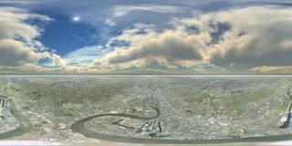 How to create an aerial panorama from Google Earth
The concept is simple — grab a series of screen shots while rotating above the earth and then stitch the images as if they were normal photographs.
A day is a long time in Internet based tutorials and this is now an update of the original as a result of Gaby, a digital urban reader, writing a kmz tool to dramatically simplify the process of capturing screen shots. The whole process should take approximately 40 minutes.
[Read more]

 How to create an aerial panorama from Google Earth


No comments:
Post a Comment